Introduction: A New Era of Blue-Carbon Measurement
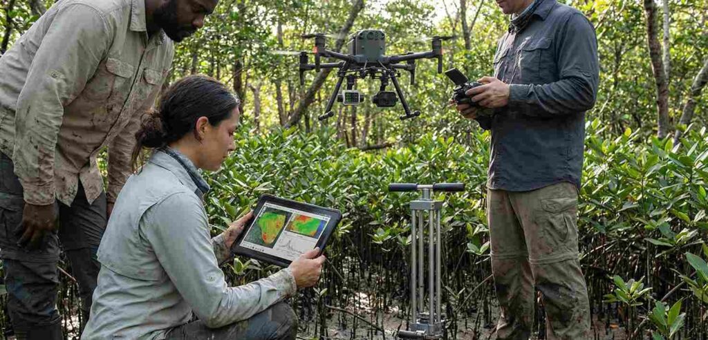
Hyperspectral Satellites for Blue-Carbon Monitoring – Indonesia holds one of the world’s most powerful natural climate solutions—its vast mangrove and seagrass ecosystems. These blue-carbon environments store carbon up to four times faster than terrestrial forests, yet they remain underfunded and under-verified in global climate finance. The core challenge is measurement. Traditional carbon stock assessments require extensive fieldwork, large teams, and recurring verification cycles that are costly and slow.
A groundbreaking collaboration between Finland’s Kuva Space and WWF-Indonesia aims to change this dynamic. By deploying hyperspectral satellite technology capable of capturing detailed spectral signatures of coastal ecosystems, the initiative seeks to determine whether space-based measurements can reliably replace manual field surveys. If successful, Indonesia could become the world’s proving ground for next-generation carbon verification and a model for scalable blue-carbon reporting.
Beginning in early 2026 and extending through 2027, this project will test whether hyperspectral imaging—supported by AI-driven analytics—can deliver accurate, consistent, and transparent carbon data that meets the rigorous standards required for national climate reporting and international climate finance markets.
Why Blue-Carbon Ecosystems Matter
Blue-carbon ecosystems—mangroves, seagrasses, and salt marshes—are among the most efficient natural carbon sinks on Earth. They lock away substantial volumes of carbon in both biomass and sediment, playing a critical role in mitigating climate change. Indonesia hosts nearly 20% of global mangrove cover, making it one of the planet’s key custodians of blue-carbon storage.
Despite their immense value, blue-carbon credits account for only 0.91% of the voluntary carbon market. This imbalance exists not because of limited ecological impact, but because verification remains fragmented, time-intensive, and expensive. Traditional field assessments can take months and often fail to meet the uniformity required for carbon markets.
The global climate community faces a verification bottleneck—and scalable monitoring solutions are urgently needed.
Hyperspectral Satellites: Transforming Coastal Carbon Monitoring
Advances in remote sensing have opened new possibilities for transparent, scalable climate measurement. Hyperspectral satellites differ from conventional Earth-observation systems by capturing hundreds of spectral bands, enabling highly detailed analysis of ecological conditions.
Key Capabilities of Hyperspectral Imaging
- Species identification: Distinguishes mangrove and seagrass species with high spectral resolution.
- Biomass estimation: Accurately detects plant health, density, and biomass variations.
- Carbon quantification: Enables predictive modeling of carbon stocks based on spectral signatures and AI analytics.
- Continuous monitoring: Delivers consistent, repeatable data at scale without the cost and delay of field surveys.
These attributes make hyperspectral satellites a promising tool for blue-carbon verification, potentially enabling reliable carbon reporting for project developers, corporate buyers, and national climate agencies.
The Indonesia–Finland Collaboration
Kuva Space, known for its advanced hyperspectral satellite constellation, will work with WWF-Indonesia to map mangrove and seagrass ecosystems in two testing regions: East Nusa Tenggara and East Kalimantan. The initiative will combine space-based imaging with artificial intelligence to analyze ecological integrity and carbon stock dynamics.
Kuva Space CEO Jarkko Antila describes the initiative as building “a dashboard that keeps a pulse on the coastal ecosystem, like no other tool out there.” The platform aims to provide near-real-time insights that could support restoration projects, climate policies, and verification frameworks.
Should the project succeed, Indonesia could unlock more efficient reporting pathways for:
- National greenhouse gas inventories
- Provincial and regional conservation programs
- Blue-carbon credit generation
- Climate resilience planning
- NGO and community-based restoration initiatives
It could also encourage global markets to adopt satellite-validated blue-carbon credits, improving credibility, reducing verification costs, and making conservation financially viable for more communities.
Why Indonesia Is the Ideal Test Site
Indonesia’s coastline, biodiversity, and climate commitments create a unique setting for innovation. Several factors make it the optimal proving ground for hyperspectral carbon monitoring:
1. Global Mangrove Capital
With approximately one-fifth of the world’s mangrove cover, Indonesia’s ecosystems provide a large and diverse dataset for satellite calibration and validation.
2. Climate Leadership Goals
Indonesia’s Nationally Determined Contribution (NDC) emphasizes sustainable land and coastal management, opening pathways for new verification technologies.
3. High Demand for Scalable Monitoring
Government agencies, conservation groups, and private developers require more efficient, transparent tools to support reporting and funding.
4. Economic Potential Through Carbon Markets
Accurate carbon stock measurement could help Indonesia unlock new blue-carbon credit opportunities, increasing climate financing flows to coastal communities.
Challenges and Opportunities
While hyperspectral satellites present exciting potential, key questions remain:
- Can satellite-based carbon measurements meet the strict methodologies used in global carbon markets?
- How will satellite data integrate with Indonesia’s existing climate reporting systems?
- What accuracy thresholds must be met for long-term adoption?
These are the questions the Kuva Space–WWF collaboration aims to answer. If successful, the project could set a global benchmark for coastal carbon verification and accelerate investment in blue-carbon conservation worldwide.
Pioneering the Future of Blue-Carbon Verification
The partnership between Kuva Space and WWF-Indonesia represents a pivotal step in modernizing how the world measures coastal carbon. By shifting from labor-intensive field surveys to advanced hyperspectral satellites, Indonesia could define the next chapter of climate measurement—more precise, more scalable, and more transparent.
If the initiative delivers reliable results, it will not only transform Indonesia’s coastal monitoring capabilities but also help unlock climate finance streams that support long-term ecosystem protection.
Organizations, businesses, and professionals working in sustainability, carbon markets, and environmental management can strengthen their capacity by joining specialized programs at Mutu Institute. We also operate Carbon Nature, an NGO dedicated to advancing nature-based solutions, carbon literacy, and climate action.
Enhance your expertise in carbon measurement, ESG, sustainability reporting, and blue-carbon management—join our training programs at Mutu Institute and collaborate with Carbon Nature to drive real climate impact.
Stay connected with us for more insights, updates, and sustainability knowledge. Follow our official channels:
Instagram: carbonature_
YouTube: CarbonNature
Facebook: Carbon Nature
Website: www.carbonnature.com
For training inquiries, partnership opportunities, or direct assistance, contact us at:
Email: info@carbonnature.com
Phone/WhatsApp: 0819-1880-0012
We’re here to support your journey toward stronger sustainability performance and real climate impact.